19 December 2016

Income Maps of the Native Americans Living in the Missouri River Basin

Candice Landry and I were discussing the environmental justice issues surrounding the Stand at Standing Rock. Candice is a geographer who uses demographic and statistical data to highlight environmental justice issues in different US urban centers. Environmental justice looks at where and what portion of our population shoulders burdens related to living in proximity to degraded resources or pollution or contamination. Out of 485 counties in the Missouri River Basin, 48 host population that identifies as Native American and just more than 50% of these counties are either in the path of, or downstream of, the Dakota Access Pipeline.

To start unpacking the question of whether the environmental racism include economic prejudice, we started mapping income and comparing the situation with the Native American households, to that of their non-Native neighbors. We assessed data on households, not on individuals, so these numbers reflect incomes that could support one person, or a whole extended family of people.

We produced the following maps that show Indigenous People's household incomes throughout the counties of the Missouri River Basin. We started with assessing the median incomes throughout, and Candice found that there are significant populations living below $25,000 per year and further, populations living on less than $10,000 per year.

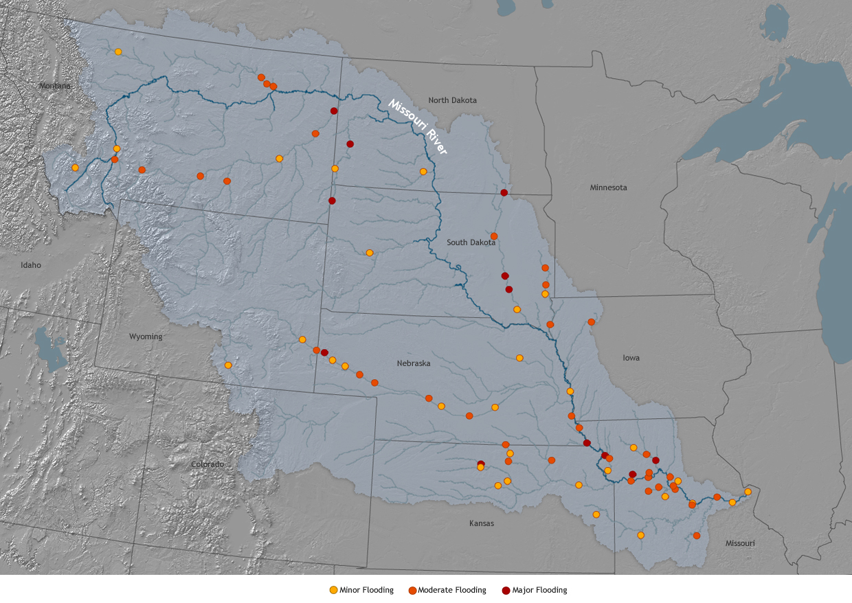
The Missouri River basin is home to more than 27 million people, including 367,649 Native Americans. Native Americans face serious economic challenges. Nation-wide median income for Native American households is $36,130, two-thirds the national median of $53,482. In the Missouri River basin, the gap is even larger where the median income is $29, 853. DAPL runs near and has a potential impact zone of many of where Indigenous People are found:


Many pockets of deep poverty—households earning less than $10,000 per year—can be found along the Missouri River and its tributaries, and many of this population living under the poverty level cluster near, or just downstream from, the pipeline route. The US Census reports that poverty level is currently set at households earning under $12K for one person or $24K for a family of four.


Is it a race thing?
In a word, yes. 
The Indigenous People were speaking loudly on behalf of their rights, the rights of the sacred land and water, the rights of the river. But why were the Indigenous People put in this position by the pipeline in the first place? Environmental racism.

Evidence about the formerly proposed route of the pipeline shows that it was planned to pass just north of Bismarck through the Missouri River. Bismarck, mostly white (Euro-American) population, rejected this proposal due to concern about threats to their water resources from a possible leak in the pipe. So to address the concerns of Bismarck, or rather to avoid addressing them, the company just moved that route to a more agreeable location - where minorities live.

Specifically, where the Indigenous People live - a particularly at risk minority group in the United States that accounts for only 1-2% of the total country population, but who are the original inhabitants of the continent - pre-colonial invasion and occupation.

Is it an economic thing?
Again, yes.
Besides ethnicity, what is the difference between the rural Standing Rock Reservation location and semi-urban Bismarck? (I say semi-urban because Bismarck is not a city in the sense of an east or west coast city, it is more of a town.) Economics. The Americans living in Bismarck have opportunity to income-generating employment allowing for accumulation of wealth, which enables them to hire lawyers and lobbyists, and in this way, they build power, otherwise known as agency, for themselves through dollar bills. The Americans living on the Reservation have limited opportunities for employment and this does not allow for accumulation of wealth, limits ability of Tribal members to hire lawyers and lobbyists, and in this way, they lack power, otherwise known as agency, for themselves through poverty.

Since working on this project, conversations I have had with non-Native Americans has been frustratingly uninformed. Most people I speak with believe that the "Indians are rich from those casinos," or "I didn't know there were Native Americans still living up there."  Candice and I discussed how many people in America have no idea about how many minority and economically challenged or poor people live here because they do not leave their socio-economic safety zone. So we decided to start mapping the difference.

These income maps highlight the already economically at-risk communities that the US Federal, State, and local governments along with the Texas-based developing company are putting at further economic, health, cultural, and wellbeing risk with this pipeline.

This four-set comparison map gives a breakdown of the Native American incomes by county throughout the basin from $25K to $10K side by side.


And this final map is a blow-up of the $25,000 and below breakout. If the household is a family of 4 people, all of these households are considered living below the US definition of poverty line on this map.


09 December 2016

Free Lecture to Update on Standing Rock at the Curtiss Mansion in Miami Springs 14 December

I will be giving a free lecture at the Curtiss Mansion in Miami Springs, FL about what is happening with the Stand at Standing Rock in regard to both the situation if you are unfamiliar and current events from Federal decisions in the last week.

Please see details from the flier and community announcement below:

06 December 2016

Water Security on the World's Rivers for Indigenous People on the radio

This past Sunday I was a guest on Natalie Krivell's University of Miami show RadioActive to speak about my water security work with indigenous people on global rivers and spotlight Standing Rock.
Please listen to the podcast and think about some of the myriad important issues raised. We have indeed entered into an era of being impolite out of necessity.

On a personal note: the show was a great opportunity to speak about the science approach I have along with the critical social issues and human rights violations. The more I think about what is happening in my country and how our government is handling it's responsibility to the people governed - especially the people who were here before this colonial system dominated, the more I am convinced it is time to change and move on. Enough is enough in the words of my Indigenous Relatives. The frustrating incompetence of elected officials to monitor indigenous cultural engagements, environmental protections, and balance corporate interests with citizen safety has spiraled out of control.

That we've just elected a guy that represents corporate arrogance and white supremacy is equally frustrating. It is hard for me to sit comfortably in my space of being a scientist and simply objective when I see this injustice. And why should we? When we are in a privileged position to witness what is happening in an intimate way around the world, we also shoulder the burden of that responsibility. So often I meet scientists uneasy about making that step forward, to reveal what they find that is related to, but outside of their scientific research. We all need to step it up. I am doing what I can right now, but I know I need to do more.

I think of so many people I know hungry and thirsty for inclusion and empowerment in seemingly impossible hard power, soft power dynamics. I also think of the people I know who hide away in their bubble or in their room, taking substances to dull the pain, and convince themselves that being comfortable is what they deserve to be. They justify that while others suffer, they've experienced suffering and wear it as their badge of exception. Or that they are somehow superior - these people coincidentally have white skin. They are still privileged even in their broken and dysfunctional states and in that position can offer their power to those who need it most. How to convince those people to feel their guts, use their hearts, and step into this transition moment?

What will you do?

23 November 2016

Upcoming University Panel on the Stand at Standing Rock

Indigenous Water Protectors and the Dakota Access Pipeline Controversy: Implications for Protecting Global Water Security, People, and Environmental Resources
Panel Discussion


30 November, 7-9pm

Florida International University MMC (main campus) Building PG5 Room 153

Florida International University asked me to help organize a panel on the topic of the Stand at Standing Rock - Indigenous People's rights in America and US Government preference for the oil industry in claiming energy security priority over water security, food security, and human security. In a remarkably quick turnaround - three FIU groups came together to make this happen:
  • The Global Indigenous Forum
  • The GLobal Water Security Forum
  • Studies of Spirituality


For this panel Faith Spotted Eagle, an Elder from the Yankton Sioux Tribe and Treaty Council member, as well as member of the Brave Heart Society, an indigenous society for grandmothers to keep Dakota Tradition, will be our Keynote Speaker. She will be joined by Bob Billie, spiritual leader of the local Miccosukee Tribe, Sam Tommie environmental activist and filmmaker from the Seminole Tribe, Dennis Wiedman medical and environmental anthropologist who works with Indigenous Peoples in Florida and Oklahoma as well as Director of FIU's Global Indigenous Forum, Manuel Gomez lawyer working on the Chevron oil case in Ecuador with Indigenous People, and I will moderate and contribute as a water security geographer and river scientist working with Indigenous People on conflicts of modernity in the Nile, Mekong, and now the Missouri basins.

I hope you can join us for this discussion about one of the most pressing issues in America at this moment in time.


21 November 2016

07 November 2016

High Country News Piece on Our Missouri River Standing Rock DAPL Water Security Research

Thanks to journalist Lydsey Gilpin, the team's ongoing research efforts were highlighted this weekend on High Cuuntry News website, a news source that focuses on the American West people and environment. The article, These Maps Help Fill the Information Gaps About the Dakota Access Pipeline, traces the impetus for why I put together the team and then what we've produced so far. The maps that I along with Drs. Mariya Pak & Candice Weems created were featured. Very exciting for the team and helps create more visibility about our narrative, which is taking the part of the indigenous story - one that is being told only marginally in the news.

Our team's work is collecting scientific basis to highlight threats to the Missouri River Basin human and ecological systems from the exemption permitted Dakota Access Pipeline (DAPL).  Yes, the pipeline went through some permitting process - but it was not a normal or complete process. While DAPL has only had to put forward their project in small segments to bypass NEPA and Clean Water Act consideration, my team is attempting to pull together a quasi environmental impact assessment from the macro perspective - not what are the 1000 foot segment threats of this pipeline project to a certain place, but what is the 1172 mile threat of this pipeline project to the overall human and environmental systems? The economic, political, cultural, and environmental aspects of the Missouri River Basin, and eventually the Mississippi River Basin (the Missouri provides about 45% annual flow to the Mississippi - impacts can flow all the way to the Gulf of Mexico. And we are most interested in the minority that are vocalizing their discontent - the Indigenous People, the American Indians, the Native Americans - several names for the same group of people - the people who are leading the movement in North Dakota and around the country.

The team keeps expanding - we are collectively identifying the gaps in the story - the largest one of all is the voice of the Indigenous People of the United States of America. 

05 November 2016

New Water Security of the Missouri River Project Page

On my website, I put up a simple project page for:

Water Security of the Missouri River and Potential Impacts from the Dakota Access Pipeline on People and the Environment Project

You can find high resolution images of our two published maps and there are more maps in the making as I write this. Also, I am creating a list of the some of our team members, so you can get an idea of the interdisciplinary background we collectively possess. Our potential projects are listed  and I hope in the coming weeks we will start to populate those links as well. For now, they are simply - coming soon.

I am putting out a public call for anyone interested to help out with small pieces of what we are doing. There are many tasks that take 3 -5 hours of concentrated attention. Please let me know if you want to work on something by contacting me through my website.

Thanks!
J


04 November 2016

Fundraising, Please Contribute So Our Research Gets Back to the Tribes

I am currently fundraising to send myself back north to share the analysis and work my team has pulled together this last month. So far I have raised close to half of the amount I need for logistics - total is estimated at $3000 for airfare, ground transportation, hotels, food, materials, etc.

My trip is scheduled for mid-November, I have bought the plane tickets already, and I plan to bring our new maps, a report, and more dialogue for collaboration with the Elders I met in Standing Rock on my last trip. Since this is a collaboration with the Tribes, I require their input about where we are taking this work and we would like to do this face-to-face meeting.

We would also like to further discuss plans for continued collaboration in mapping the oral histories and traditional knowledge from the Tribes about the landscape in the Missouri River Basin. I am currently looking for funding for that as well, but that is another situation!

Please consider contributing to my fundraiser, every dollar counts.

Thank you!
Jen


02 November 2016

Two Maps that Describe Water Security Threats from DAPL for the Missouri River and Indigenous People Living There

*Edit : Please see our webpage for additional maps and information.

My team has produced two new maps to describe the situation of the threats from the Dakota Access Pipeline to the Missouri River water security for humans and ecosystem - particularly the population at risk of Indigenous Peoples.

While our maps are focused on the Missouri River, which contributes close to half of the annual flow to the Mississippi River, the pipeline also crosses the Mississippi and just last week the pipeline construction under the Mississippi was completed. This means that although we are focused now on water security of the Missouri - this pipeline threatens the water security of the Mississippi River as well - a threat that carries all the way to the Gulf of Mexico. But that may take a larger study and more time and resources...

The maps:
While this map focuses on the Indigenous Populations at risk, please keep in mind that major city centers such as Kansas City, Sioux City, Omaha, and St. Lois are also at risk. In fact, there are about 2000 urban centers in the Missouri River Basin. This brings the number of people potentially impacted by a pipeline failure into the tens of millions. 

This first map shows the relationship with where the Tribal Lands are held, the proposed pipeline route, where the proposed pipeline route crosses major waterways (there are hundreds of minor ones), and who lives downstream of those crossings - so who is at risk. This shows where Indigenous People are at risk. We have the names of the waterway crossings identified and listed, and the Tribal Land names downstream from those crossings listed.

What do I mean about Indigenous People at risk? I read a well researched but extremely biased piece about how the Indigenous claim to this pipeline problem is false. That the water intake is not even the primary intake for the Standing Rock Reservation drinking water supply. I am not only concerned with drinking water, although that factors in of course - Kansas City also sources their water from the river, by the way...

Water's biggest use is for agriculture. This is world wide. But water is also used for cultural, religious, and social reasons and this is often overlooked as an important and significant use of water.

Water, for Indigenous People world wide, holds sacred and special significance. Much like for the Christians, water is used for baptism, or Muslims water is used to cleanse before prayer, water for Indigenous People features into religious observance and practice, the spirit of the river itself is of vital importance - and this means that the river, the water, is sacred. So how the river is treated and managed is important not only for consumption, but for identity, prayer, and community. Many of the Indigenous People in question with Standing Rock and the DAPL conflict are river people, as is shown in Map 2 below. This is why, in my opinion, the Indigenous People are calling themselves water protectors. So, if the water is contaminated by oil, there is cultural and religious significance that is ruined or desecrated as well as human health risks and ecosystem health risks - so why would we want to take that risk?

Isn't it illegal to limit someone's religious freedom in this country?

The ecosystem is getting only a vague nod by the Feds. Two birds and fish are listed as endangered in the Missouri River mainstem. I featured them in a post two weeks ago. While this pipeline threatens their already altered and shrinking habitats, oil and hyrdofracking for oil upstream in the Bakken (which is contributing hydrofraking fluid to the Missouri River) is also ruining aquatic habitat and threatens to push more species into a threatened or endangered status. The ecosystems are also very important to Indigenous People's culture and religion. Damage to species of plants, animals, fish, birds are also a threat to Indigenous People in this way.


This second map is a demographic map that shows where populations of people live by county. In this case, we are interested in the percentage of Indigenous Population by US county in relationship to the waterways and the pipeline route. You can clearly see in this map that the Indigenous People living in the Missouri River Basin live mainly along waterways. They are largely river communities and river peoples - connected intimately with the rivers. The importance of the water for the Indigenous People population can be recognized in their presence and proximity to it. Again you can see the populations at risk, downstream of the pipeline route waterway crossings.


01 November 2016

Public Talk about Standing Rock & Water Security this Saturday in Miami


Text Box


On Standing Rock Sioux Reservation in North Dakota, Native American Tribes are standing against development of a 1,172 mile oil pipeline. Mississippi Rivers. The Dakota Access Pipeline, or DAPL, is designed to cross hundreds of waterways including the Missouri and Mississippi Rivers.  

ImageWater protectors are led by indigenous peoples and joined by non-native allies from around the country and world. More than 240 recognized Tribes stand in solidarity with Standing Rock against this threat of potential contamination of our longest and largest national water basins. This moment is unprecendented in contempoary times: this is the largest gathering of Native American Tribes. They stand unwavering under the banner of Mni Wiconi, Lakota words that express: Water is Life 

Jennifer will share the story of the movement as she understands it, her trip to North Dakota, and her current research efforts toward understanding and describing threats to water security for people and ecosystems from this development.  

Talk & Photographs by Dr. Jennifer Veilleux  
Luna Star Café – 775 NE 125th Street North Miami (305) 799-7123 
Saturday November 5, 2016 – 3:00pm $10.00 Cover  
Fundraising Event for International Indigenous Youth Camp at Standing Rock, Live Music to Follow 

19 October 2016

Endangered and Threatened Species in the Missouri River

Jon Eagle Sr. of the Standing Rock Lakota-Sioux Reservation in North Dakota told me that there are two birds and a fish threatened and endangered species in the Missouri River Basin. 


Here is the endangered pallid sturgeon, an ancient fish type:
And a paper published in 2015 shed light on why this species is endangered - anoxic zones (areas of very low oxygen in the water) due to damming the Missouri River. In other words, humans engineered the river and now yet another species of fish cannot survive the change.

Then there is the cutie pie piping plover - I participated on a study of breeding pairs of piping plovers on the Connecticut shoreline more than a decade ago and fell in love with these birds - they breed on the shores of Lake Oahe, one of the main crossing areas of the Dakota Access Pipeline. These birds are threatened - endangered populations also exist in the Great Lakes region.
And finally the Least Tern. Since this bird lives and nests on sandy islands, its habitat has been either removed or encroached upon by humans and the engineering of the Missouri.  


The Dakota Access Pipeline poses a threat to the already problematic habitat loss and change due to human engineering to the Missouri River Basin.  


Missouri River Basin Water Security Threats from Climate Change

Working on a US river basin is proving to be the opposite of my usual problem of not enough data - I am practically drowning in it! The Center for Research on the Changing Earth System, CRCES, out of Maryland that has conducted research on the Missouri River Basin's water security vulnerabilities related to climate change. Their webpages contain useful information about the basin that I am examining to include in our water security threats and vulnerability assessment related to development (DAPL in specific). The page has some useful maps, reports, papers, and other resources worth checking out if you are interested in a better understanding of the basin.

Up front, the page tells us that the Missouri River Basin accounts for almost half of all the wheat production and more than a third of cattle production, valued at over $100 billion USD in 2008, the year we had an economic crisis.

I'm also finding a slew of interesting maps of the Basin. This one from the US Army Corps of Engineers shows just how big the basin is over the landmass of the United States - unfortunately the mapmakers cut the watershed off at the border - it actually covers territory in 2 Canadian Provinces as well.


Another map from the US National Oceanographic and Atmospheric Agency (NOAA) highlights where likely flooding will occur in the basin due to effects of weather and climate events.

The Missouri is the longest river in the United States and connects into the Mississippi - which makes a hydrological connectivity that reaches the Gulf of Mexico. This is demonstrated in the complex but all inclusive map of the Mississippi River Basin from Wikipedia.

This map from the Kansas Department of Agriculture (I did not know that individual states had departments of agriculture before now) highlights the 6 main reservoirs along the Missouri operated by the Army Corps of Engineers and also that the water in the river is an important resource for Kansas City residents. 


And the World Resources Institute classifies stressed river basins - they include the Mississippi (in which the Missouri lies) as moderate to high water stress.


And finally, for this post, a map of the average flow of rivers across the United States (note the basins all end at the border for political reasons, not natural reasons) from the offices of well-known water security scholar, Peter Gleick.


18 October 2016

Rescheduled Smithsonian Event This Thursday Evening 6:30 - 8:00 at Curtiss Mansion

RESCHEDULED EVENT FROM 6 OCTOBER HURRICANE MATTHEW SHUTDOWN

On October 20, 2016 from 6:30-8:00pm I will be moderating a panel of experts for the Curtiss Mansions' Smithsonian WaterWays Exhibition on South Florida Water Challenges and Solutions. The panel will include experts from University of Miami, Florida International University, and Miami Waterkeeper not-for-profit organization.

You can see the Curtiss Mansions' website for more details and for the panelists' bios. If you are in Miami, please plan to attend. The discussion should be both lively and informative!

17 October 2016

Dakota Access Pipeline (DAPL) Environmental Assessment

If you are interested to give a read of the Dakota Access Pipelines Environmental Assessment, that passed muster with our government, please see the document itself:


16 October 2016

Standing Rock Stand Against Water Defilement

To protect water ensures security for ecosystems, people, the river itself. The Indigenous Peoples of America and the world are leading us toward a sustainable tomorrow, if we are only willing to follow.

I have just returned from a field trip to North Dakota water protector camps on and near to the Standing Rock Lakota-Sioux Reservation. If you have not heard about this historic and monumental event, please read more about it on Sacred Stone Camp's website. They have collected dozens of news articles about the situation. As I understand it...
 
Delwin Fiddler holds open a Water is Life Banner at Oceti Sakowin

 Camp


THE ACTION Indigenous Peoples and allies from around the country (the count is up to more than 245 Indigenous Tribes) and world have come together in North Dakota to stand against an oil pipeline called the Dakota Access Pipeline or DAPL for short. This unification of Tribes is unprecedented. The stand at Standing Rock Reservation is along the Missouri River and Cannonball River confluence and is full of people of all ages, native and non-native alike. People are staying in secure camps near to the construction of the pipeline. Those who have come there identify as Water Protectors and are putting their lives and bodies on the line to prevent development of an oil pipeline crossing the Missouri River. The camps are full of prayers. Groups of singers, drummers, flute players, and dancers share their performance as medicine for healing and strength.

THE PIPELINE This 1,172 mile pipeline is designed to cross the Missouri River and the Mississippi River as well as 8 other tributaries of the Missouri - as I wrote about previously, but as I learned in North Dakota, will cross 209 waterways in total. The pipeline company is called Energy Transfer Partners and is based in Texas, but has assets all over the United States. They state on their website that they are aware of Environmental Regulations and abide by them. If this is the case, why did they choose to fast track their pipeline construction, thereby bypassing Clean Water Act and NEPA regulations for proper Environmental Impact Assessment on the totality of this megaproject? What I am talking about is that the company, with the permission of the Federal Government bodies that could call them out on this and enforce otherwise, used a loophole in the law created for small-scale infrastructure projects. They broke their project impact into 1000 foot segments and assessed under those required guidelines - a much less rigorous and costly method to ensure environmental safety and compliance. This is a mega project and needs to be assessed as such. There is a reason why these laws are in place in the first place and finding ways around the law only serves to dilute the effectiveness of environmental policies.

Pipelines leak. There are some good technologies out there that can minimize threat and failure, but there is no full-proof design for leak-proof pipelines. This particular pipeline will move through 4 states and 40 counties, but a breach could impact a much broader swathe of America through contamination of both the surface and ground water.


THE GOVERNMENT'S RESPONSE  Currently, the state police and national guard are being used to protect this private company's interest - in other words, tax payer dollars are being used for corporate interests. This coupled with the taxpayer dollars required to clean up oil spills over the years puts public interests aside for private profit.

Additionally, at least two people are being charged with either participating in or inciting a riot, when in fact both of these people were filming the North Dakota police, pipeline security, and water protector clashes. Tomorrow we will see where the courts are going with such a charge and whether or not this goes anywhere - if either person is convicted they will be considered political prisoners, something that happens in other countries frequently and why many people seek asylum in America - we have Right to Free Speech, Freedom of the Press, and Right to Assembly. This is getting a bit confusing as well because people are being arrested for exercising their First Amendment. In case you need a refresher (I know I did):

In the First Amendment to the United States Constitution it states: "Congress shall make no law respecting an establishment of religion, or prohibiting the free exercise thereof; or abridging the freedom of speech, or of the press; or the right of the people peaceably to assemble, and to petition the government for a redress of grievances" (Bloom p. 81). The right of a citizen to peacefully 1) parade and gather or 2) demonstrate support or opposition of public policy or 3) express one's views is guaranteed by the freedom of speech and the right to peaceably assembly..

On September 9th the Department of Justice put forward a statement that they would be meeting with Tribal members across the country this fall to discuss two items (no doubt related to what has been inspired at Standing Rock):
1. within the existing statutory framework, what should the federal government do to better ensure meaningful tribal input into infrastructure-related reviews and decisions and the protection of tribal lands, resources, and treaty rights?
2. should new legislation be proposed to Congress to alter that statutory framework and promote those goals?

Meetings have already occurred in Phoenix, Arizona and will continue this fall. I am interested to hear what the Tribes call for from the government in light of continued infrastructural development encroachment on water, land, and resources guaranteed through the Treaties (for a complete list, University of Oklahoma has a database).

THE MEDIA'S ROLE
Traditional media has done a crap job covering this event. People have been camped near the river since April. The camp swelled and an overflow camp was established over the summer. This fall, people are digging in for the winter. Yet, not much of anything has appeared on the evening news, and barely anything about this in the newspapers. This is news. I cannot believe that the elections need that much airspace that not one story can be shared about this.

When an article does get published by a mainstream outfit, such as the recent New York Times article by Jack Healey (you can email him at jack.healy@nytimes.com to let him know what you think) the coverage is painfully biased and poorly written by junior, inexperienced journalists and photographers (the photos look like the photographer didn't get out of the vehicle, & the voice-over by the author is amateurish at best). 

If you want to know about Standing Rock situation, it is best to check social media. Some of that has not been cooperating and working properly either. Some people think that the media black out is on purpose. Some people experience that social media is being limited - such as some functionality of Facebook has been acting unusual - such as the live feed or videos not posting properly or in a timely fashion.


THE BOTTOM LINE
People who care about the security of the water are taking a stand in North Dakota. This is another in a trend of actions taken across the country of people standing against the irresponsible development fostered by a broken Federal permitting process that is overlooking its own law and policy. Clean Water Act. National Environmental Policy Act. Endangered Species Act. These decisions were put in place for a reason. Touting "National Security" reasons for building a pipeline to process crude oil that will most likely sell to the highest bidder - not necessarily for domestic markets - does not trump the need for this Energy Transfers company to follow regulations like everyone else. Water is our most important national security issue. Wake up Washington.

***

To protect water ensures security for ecosystems, people, the river itself. The indigenous peoples of America and the world are leading us toward a sustainable tomorrow, if we are only willing to follow.

07 October 2016

Water Security of the Missouri River and DAPL Part 2

Our team has been working together to pull together initial data produce some initial analysis of the water security of the Missouri River Basin as related to this Dakota Access Pipeline. First draft of Missouri River Water Security and Dakota Access Pipeline maps are in and initial analysis reveals a few things: (I will share these on here after we have the final drafts completed)

  1. The proposed path of the Dakota Access Pipeline is currently designed to cross the Missouri River/Cannonball River confluence where the Standing Rock protests are positioned, as well as 8 other tributaries to the Missouri and downstream, there is a proposed crossing on the Mississippi River.
    • This means that the pipeline not only threatens the Missouri River water resources in one crossing, but in 9 crossings - each tributary carries water (and whatever is in the water) to the Missouri River.
    • These 9 crossings are upstream of the Mississippi River and there is one more crossing on the upper Mississippi - which also sustains a sizable population and economic (including agricultural) interests.
  2. There are six sizable Native American communities living on the main Missouri River that could be directly impacted if there is contamination from oil leaking or spilling at 4 of the proposed 10 crossings.
  3. The pipeline also looks to cross closely to heavily populated areas in Des Moines, IA and Sioux Falls, SD.

Questions this brings up for me:

  1. What is the number of people relying on Missouri River water for a domestic water supply?
  2. What is the economic impact of a change to water quality from a potential oil leak or spill - to communities, businesses, people, the environment?
  3. What are the water quality standards of the Missouri River currently?
  4. Can those change?
  5. Who is responsible if there is an oil leak in the Missouri River Basin?
  6. Where is the overall Environmental Impact Assessment of this project?
  7. Who are the stakeholders? 
  8. Who influences decisions about water in the Missouri River Basin? Are these people actually stakeholders? In other words, do the people making decisions stand to lose if those are poor decisions?
About our team:
I put out a call to build a team of colleagues who have experience in technical and subject or contextual aspects of a geographically based effort toward understanding the socio-ecological water security of the Missouri River. I was overwhelmed to hear back from eight people that hail from Asia, Europe, Africa, and North America willing to roll up their sleeves and help with this work.

So far - we have mappers - geographers &cartographers pulling together available data from online to get a better understanding of the spatial relationships of water to people to types of communities to state boundaries to the pipeline, etc.
We have content researchers building an events and online sources database - we are culling the internet for social and traditional media sources of information on the pipeline and the current water conflict. This database, once we have finished populating, coding, summarizing, and conducting a content analysis will ultimately live both on a webpage of my personal website and with Aaron Wolf's Transboundary Freshwater Dispute Database at Oregon State University. We currently have 60 records coded and in the process of being summarized in preparation for analysis.

And we have a historian and water lawyer helping to fit in the policy, treaties, and official agreements about water and land in the Missouri River Basin.
In the wings there is a demographer and women's health specialist looking to contribute. And I am just discovering information about farmers and landholders near to the Bakken fields (within the Basin) who are dealing with salt water contamination to their soils due to brine dumps from hydro-fracking.

Standing Rock is serving as a platform of unification for indigenous peoples from all over the country and the world, as well as people concerned with the environment and concerned with water. Let's keep this going - I hope to learn much more on my upcoming trip to North Dakota.

Something to note: I've noticed in the online news is that the pipeline company has not stopped laying pipe. I am not sure I understand the situation completely. Court ruling this week in DC is that there is a delay in deciding about the current delay in laying the pipe across the river. We still have time to highlight why this project needs to be reconsidered in its current form - and this is connected to environmental considerations in the Bakken fields, as well as moving oil along two of the most significant river valleys in the United States of America - the Missouri River is the longest river, the Mississippi is the largest catchment - both rivers are transboundary: shared between countries, states, counties, tribal land, municipalities, public land, and important and threatened ecosystems that contain endangered species.

If you want to join our team with your expertise, please get in touch as soon as possible!

28 September 2016

6 October 2016 Panel on South Florida Water Challenges and Solutions


On October 6, 2016 from 6:30-8:00pm I will be moderating a panel of experts for the Curtiss Mansions' Smithsonian WaterWays Exhibition on South Florida Water Challenges and Solutions. The panel will include experts from University of Miami, Florida International University, and Miami Waterkeeper not-for-profit organization.

You can see the Curtiss Mansions' website for more details and for the panelists' bios. If you are in Miami, please plan to attend. The discussion should be both lively and informative!


27 September 2016

Dakota Access Pipeline and Water Security of the Missouri River


This will be the first of several posts about the importance of the Missouri River's water security. The Missouri is a transboundary river basin shared by the US and Canada, and is the longest river in North America. The Missouri is a tributary of the Mississippi River the river with the largest catchment in North America. These two rivers are the two major rivers (probably the most important rivers in the United States) that millions of people rely upon for farming, water supply, water sink, transportation, hydropower, and recreation.

If you have been following the news, mostly on social media, there is an issue of a petroleum pipeline designed to cross private and public land, taking oil from the oil fields of North Dakota's Badlands area out to the another access point in the midwest. The Dakota Access Pipeline is designed to pass under or through the Missouri River. It is also designated to pass through sovereign land of indigenous tribal people of the United States. This has created a situation that is being poorly covered by the press for some reason, but has gotten violent and also has gotten the attention of the President of the United States. I am going to try and better understand and describe why this pipeline is linked with water security concerns for stakeholders.

Pipelines are notorious for leaks. 

This project threatens the Missouri River's water security. Water security is a term used in international context in academic and development circles to describe the general health of a water system for people and ecosystems - typically the term describes access, quality, and quantity for sustainable livelihoods and life. When a river's water security is called into question, the impact is far reaching to any communities living downstream. In this case, the protesting tribes state that this river is their water source. When it comes to water, there are few viable alternatives - and when surface water is contaminated with oil, ground water is not far behind. Everything is connected in the system.

Tribes across the United States, Canada, and South America have joined forces to protest the pipeline. The reasons are multiple - to include violation of sacred lands, violation of culturally important burial grounds and other spaces, and the crossing of the Missouri and threat that presents to water quality downstream users.

Over the course of the next weeks I will look into the water security of the Missouri under a pilot project in hopes of a larger study. I travel to North Dakota in October to speak with people on the ground. So far, I am going on my own and I hope to be able to collect photographs, interviews, and audio/visual recordings from the place where people have gathered. I am especially interested to speak to those who are speaking out about the river itself.

While I have conducted water security assessments on other transboundary river systems around the world, this will be the first time I will attempt a comprehensive analysis of a river here at home in North America. I plan to collaborate with other researchers to create maps and other important research products to help in visually communicating the science, as well as write about it. This is exciting.

Please stay tuned.

15 July 2016

Notes from the Field: stories from the water security project I currently participate on in Tanzania.

I have published notes and impressions of experience from a field team I went out with in Tanzania earlier this year under the "News" section on the SELVA website. These posts are interesting stories about the Mara River in Tanzania, a river that originates in Kenya and passes through landscapes that include agricultural land, cattle grazing areas, a natural reserve and national park, mining and fishing zones, and a major wetland before contributing to Lake Victoria. Our field team, under the Serengeti Lake Victoria (SELVA) Sustainable Water Initiative, included professionals and scientists from the Tanzanian government and Florida International University. Check out some of our stories and photographs!

Mara River at Kogatende Bridge, Serengeti National Park, Tanzania
Jennifer Veilleux © 2016

18 May 2016

26 May 2016 Speaking Engagement in New York City

I have been invited to speak in NYC on the evening of 26 May at Midoma Gallery for the closing party of artist Ariel Shallit's Iconic: re-imagined show. You can check out the details on my website news and read more about our collaboration work - my portrait photography of indigenous river communities before displacement and his overpainting technique to combine art and science for advocacy. I am quite keen on sharing the story of the people I have met around the world who are experiencing community instability and threats to their identity, health, and well-being due to the wave of water development on rivers. River communities of indigenous are losing their way of life and this is being categorized as an economic externality or a political blip on the RADAR.

I feel I have failed a bit to be able to get this point across in academia sometimes as responses from my audience sometimes ask why the Gumuz (and you can insert any indigenous group out of the national economic system here) matter? Other times I am asked whether I really thought that local people wouldn't prefer buying their fish at a grocery store to having to fish in the river. And yet more have voiced the need to modernize the traditional communities who are "primitive" or "backwards" and need help.

As one recent reviewer wrote on an academic paper that I unsuccessfully submitted for publication - "The Gumuz are being displaced, others are not, so this is obvious and does not need human security [analysis] or interviews in the field."

I hope I can improve my scholarship to clarify the point that development may have it wrong - and in fact may be an absolutely dangerous path with no return. I hope to communicate clearly that every sort of people matter, traditional lifestyles and knowledge are valuable, and people have the right to determine their own identity and livelihoods. Until then, I will start to really move on advocating through art and collaborations with artists to get the message out - maybe if people are unable to understand the dignity of people in my words, they can understand through the images I take.

The engagement information is below if you are in the NYC area next week and would like to attend. No cover.


12 May 2016

World Bank Report on Water and Economics Link

If you are curious to read the World Bank's report on water from their perspective, you can access the full report from their site (or you can opt out for the executive summary which is only a few pages). This report will help to explain where the Bank will be investing next and how.


11 May 2016

Inga 3 in the News Again: Talk of Selecting a Construction Company

News article released today states that Democratic Republic of Congo's Inga 3 dam project is alive and well and is moving forward this year. The news is that the project's potential electricity is being sold to South Africa's energy hungry market and Congo's mostly foreign-owned mining sector, the left-overs go to the people. This is in an energy poor country. It appears from this that water resources of the Congo will be harnessed for profit rather than for domestic development.

The Inga project, well-known to anyone interested in hydropower on the African continent, has been an idea in the heart of Congo's desire to develop and the heart of many economists that see Inga as the answer to Africa's energy needs. The siting of Inga can harness 11% of global hydropower potential - yes global not just Congo River - and this is found on one stretch of the Congo River, downstream from Kinshasa. I wrote a bit about this twice in 2013 (here is the second post) and it is the highest traffic post I've written receiving more than 4500 hits to date.

The two tenders are big companies, one of which constructed Three Gorges Dam and we all know how efficient that dam is running. Perhaps they have learned from their mistakes? With Congo's internal political challenges, it will be quite interesting to see how and when this project can get off the ground. The estimated cost of 50 billion dwarfs Ethiopia's GERD, which is the largest hydropower project being constructed on the African continent right now.

Congo to select developer for Inga 3 hydropower plant by October

Tue May 10, 2016 3:08pm GMT
[-Text [+]

By Aaron Ross

KINSHASA May 10 (Reuters) - Democratic Republic of Congo will decide by October between a Chinese and Spanish consortium to develop the long-delayed Inga 3 hydroelectric project with construction expected to begin the following June, a government official said on Tuesday.
The $12 billion project along the Congo River will expand on two existing Inga hydroelectric dams and is part of an eight-stage Grand Inga project that would produce a record 44,000 MW at an estimated cost of $50-80 billion.
Proponents of the project say that it could eventually power half of Africa, while critics say that the money would be better used supporting smaller local plants.
The Chinese consortium is led by China Three Gorges Corporation while the Spanish one includes engineering giant Actividades de Construccion y Servicios SA , said Bruno Kapandji, the head of the Agency for the Development and Promotion of Grand Inga.
"We are waiting for their bids in the month of July," Kapandji told Reuters. "We will choose the one that will be the best in terms of experience, capacity to mobilise funds, capacity to mobilise technology."
Of Inga 3's 4,800 MW, 2,500 will be sold to South Africa and 1,300 is earmarked for Congo's mining sector. The remaining 1,000 will go toward meeting domestic demand in a country where less than 15 percent of the population has electricity.
The start of construction has been repeatedly delayed by red tape and disagreements between Congo and its partners on the project, including the World Bank and African Development Bank, which have provided technical assistance.
Kapandji said he expects construction to begin in June 2017 and last four to five years. Congo had originally promised South Africa power from Inga 3 by 2020. 
However, he said that the project still needed to secure additional financing. He declined to say how much money had already been mobilised but said that possible investors were attracted by the project's potential profitability.
Kapandji also defended the controversial decision last October to move control of the project from the prime minister's office to an agency within the presidency, which has raised concerns about corruption and political interference.
"It's the head of state who pilots this programme," he said. "First of all, that secures the project itself. Also, that reassures our partners and, above all, our clients."
(Editing by David Evans)