14 October 2014

Story on Lao Traditional Fishing in the Mekong in Global Context

Just published a new story on The Curious Human: a comparative piece about traditional dipnet fishing in the USA in the Columbia River basin and dipnet fishing in Laos in the Mekong River. The two communities - the Yakima Nation and the Laos - use traditional fishing practices to harvest migrating fish in fast flowing rivers. The comparisons between the communities who have no contact between them are quite interesting. The threat that progress has on these practices, in both places, through water development, new fishing tools and techniques, changing policies, and increased populations is similar. That the Yakima are still fishing traditional fishing grounds in the Klickatat River amid the modernized sterile world around them gives testament to how dipnetting is not only a useful technique, but a preferable one. Hopefully despite modernization and development in cultures like the ones compared in Laos, will also retain their traditions and uses of the river. In the case in Laos, it will have to be in a different part of the river due to the related flooding of the area after the Xayaburi Dam is complete.

Check out The Curious Human for similar compelling stories.

Traditional Fishing: 2 Cultures, 2 Rivers

20140925_171451
KLICKATAT RIVER IN WASHINGTON. NON-NATIVE FISHERS (LOWER RIGHT) USE LINE AND HOOK FROM THE SHORE. © JENNIFER VEILLEUX 2014
I recently took a camping trip in the Columbia River Gorge, a few hours from where I live in Oregon. Summer is ending, the days are getting shorter, and the salmon have returned. Fishermen and hunters fill riverside campsites. Boats start their engines about 4:00 a.m. and gear is prepared the night before. The salmon are swimming upstream to spawn.
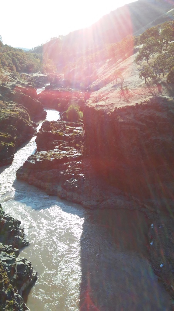
I had no real plan or agenda for my time in the Gorge. I had a vague timeframe to get back home. I thought about hiking the waterfalls. Instead, I pulled off the highway to see the visitor’s center at The Dalles dam. The center was closed, but a man in a white pickup truck pulled up while I was standing in the empty parking lot. He told me he is from the Umatilla Reservation and works as a fish biologist for the Warm Springs Reservation. After a long conversation about lampreythe dams, and the local tribal rights, he said, “If you have time, go over the bridge here [from Oregon to Washington over the Columbia River]. Drive west on the Washington side of the river. You will come into a small town of Lyle. Take a right where you see a sign for the Klickitat Trail. About 2 miles up the road you will see a two bridges, one is a footbridge. Stand on the bridge and look down. There, you will see the Yakima People fishing for salmon using traditional dipnets in the Klickitat River. It is one of the only places left in the Columbia River basin where Native People fish like this. You have to see it if you have never seen it before.”
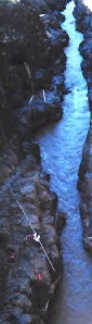
I headed over the river, following his directions. I found the Klickitat Trail sign, drove up the road to the two bridges. I got out and looked over the edge of the bridge. There I found the deep ravine of the upper Klickatat River. I saw far below in a steep sided rock gorge, two men, one young, one old, fishing with long poled nets.
Edited_fishers
TWO YAKIMA MEN FISH WITH DIPNET IN THE KLICKATAT RIVER © JENNIFER VEILLEUX 2014
The men took turns fishing. They were tied into a rope system by the waist, attached the the rocks behind them. I watched one man pull out a beautiful huge silver salmon. I noticed that the dip net had closed around the fish. The man brought the fish out of the water, hauled it onto the rocks, and took it from the netting. The fish flapped with incredible strength, beating the air and rocks with its tail. The man beat it over the head until the flopping turned into vibrating fins and finally into no motion. The fish, still, was shifted into a black bag waiting on the rock shelf.
The next man roped in. I watched as he patiently pulled his net on the long pole through the water. With each pass, the net began strung along the entire hoop and came out all bunched up at the far end. Each pass necessitated the need for the netting to be restrung around the hoop.
20140925_180243
SYL SPINO OF THE YAKIMA TRIBE HOLDS A 9 FOOT DIAMETER DIPNET. KLICKATAT RIVER, LYLE, WASHINGTON © JENNIFER VEILLEUX 2014
Long pole dipnetting. Klickatat River, Lyle, Washington © Jennifer Veilleux 2014
LONG POLE DIPNETTING. KLICKATAT RIVER, LYLE, WASHINGTON © JENNIFER VEILLEUX 2014
Syl Spino, a man from the Yakima tribe, got out of his car where he’d been watching me and approached to ask, “have they caught anything yet?” I said “yes, one.” He joined me to watch the two men below us fishing in silence. After ten minutes of this we started talking about the dip netting tradition.
Syl said he had just given a demo to his granddaughter’s class at school on the tools for dip netting. As he explained, the older man of the pair pulled in a fish with a bit of a struggle. It was huge. He did the same process as the young man had done before him. We watched and talked as he hauled in fish after fish. I speculated that there must have been a group of them running together upstream.
Syl offered to bring me to his car to show me the hoop, the metal netting material, the net making tool, and the needle that threads the netting. He had a wooden needle his grandfather made, and a replica metal needle he had made from the model. He wasn’t as happy with the replica. Syl explained that each net must be made of these separate parts and how much each piece of material costs. The hoop itself is fixed to a wooden pole. The wooden pole is fitted to a long aluminum pole. The poles can be 30 to 40 feet in length. I held the hoop to feel the weight and thought about the metal netting, the aluminum pole. “Do many women fish?” I asked. “There are a few,” he told me. Each fish weighs 25 to 35 pounds. No wonder why the men were roped in. I asked, and he explained it is a law that fishermen must rope in.
Lylefishpassage
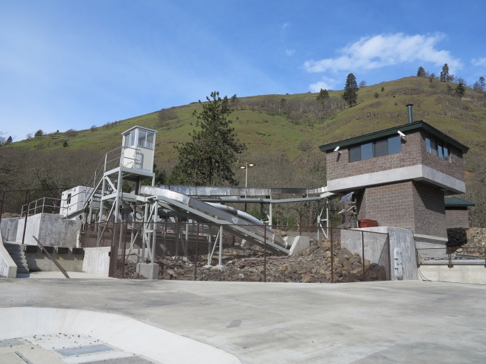
FISH PASSAGE ON THE KLICKITAT RIVER, COURTESY OF YAKIMA/KLICKITAT FISHERIES PROJECT.
Syl suggested he could take me up some dirt roads to see a fish passage facility where his son works. The facility keeps track of the fish species, sex, and whether the Klickitat River fish returning to spawn are wild or farmed. Farmed fish have a clipped fin. The facility is new, a project between the Federal government and with the local support of tribal research on the migrating species upon which they traditionally depend. There are no catch limits for the Tribes. There are designated fishing areas, such as the one where we watched the fishing, where non-natives are not supposed to fish.
1898780_10151952030200233_2031582252_o
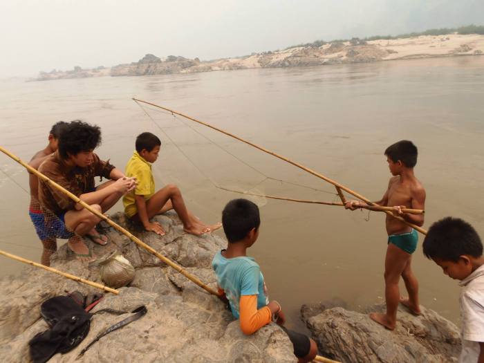
LAO FISHERMEN FISHING WITH BAMBOO DIP NET MEKONG RIVER, LAOS, PDR © JENNIFER VEILLEUX 2013
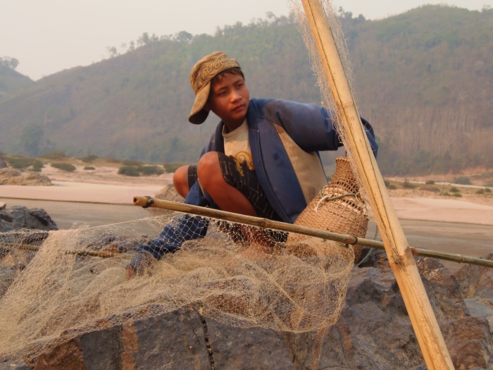
The dipnet technique reminded me of similar fishing in the Mekong River that I learned about and even tried in Laos during my Xayaburi Dam field research. In a Lao village, I spoke with and interviewed fishermen about their livelihoods. One man taught me to hold and fish with a traditional bamboo dipnet. The net was pretty large and I thought a bit unwieldy. I didn’t catch anything, but enjoyed the meditative rhythm, and the possible chance of a catch with each pass. The fish the Lao fishermen were after were fingerling sized fish, though they explained that there were different fish migrating along the shore at different times.
1796813_10151952028885233_1647345242_o
LAO FISHERMAN FISHING WITH BAMBOO DIP NET MEKONG RIVER, LAOS, PDR © JENNIFER VEILLEUX 2013
I find it curious that indigenous traditional cultures, two continents apart, have such similar fishing tools. Both communities in North America and Southeast Asia are using dipnets when the water is low, fishing from rocky outcrops, patiently scooping downstream with the current. Both the Lao village fishermen and the Yakima Nation fishermen are using materials purchased outside their community to build their nets. This type of fishing can be dangerous in both places—told to me during interviews with the Lao fishermen and apparent with the rope safety the Yakima fishermen are using. Both communities wait for the seasonal cycle fish migration, know when the fish migration should be depending on the rain, moon, temperature, water level, season and a slew of other triggers I know nothing about to predict the presence of the fish.
And in both communities, an ocean apart, fishermen are doing something taught to them by their grandparents, an activity they will teach their grandchildren.
However, traditional fishing, just like the fish themselves, is under pressure from modernization, progress, and development. Why would people still use the traditional dip netting process when more modern forms of fishing may yield a larger catch, an easier haul? What will happen to these traditions when there are no fish to migrate in a particular tributary, an area slated for traditional fishing? What will happen when younger generations decide that trolling in the main Columbia River is the only way to fish the salmon? What will happen when dams are installed in the Mekong River and fishing areas are flooded and lost?
OLYMPUS DIGITAL CAMERA
LAO FISHERMAN USING BAMBOO DIPNET IN THE MEKONG RIVER DURING DRY SEASON MEKONG RIVER, LAOS, PDR © JENNIFER VEILLEUX 2013
I breathed deeply before I drove away at sunset. I thought, here, just a few miles from the Columbia River – that endless migration of barges, cars, trains, fish, people, and water—here is a stillness, and a silence. Here is a tradition that reaches back through past time and I hope reaches well into future time—simple relationships between man and river, man and fish, river and fish.
Perhaps the presence of the Yakima Nation, the young man with the older man fishing with the dipnets is a sign of something persisting. This traditional practice has outlasted changes. There are still areas where modern development impacts haven’t completely obliterated the ebb and flow of water, the cycle of returning fish, and traditional knowledge and fishing practices.
OLYMPUS DIGITAL CAMERA
LAO BOY USING BAMBOO DIPNET IN THE MEKONG RIVER DURING DRY SEASON MEKONG RIVER, LAOS, PDR © JENNIFER VEILLEUX 2013

Story of Development and Security Research on Ethiopia's Blue Nile River in Oregon State's Terra Online

My university included a story on a portion of my research into the development of the Blue Nile River through the Grand Ethiopian Renaissance Dam. The publication is Terra, an online coverage that promotes research and research-related activities at Oregon State University. Local author Abby Phillips Metzger is a fantastic word weaver. Abby captured the complexity of the Nile River development in Ethiopia for Ethiopians throughout the country and the local Ethiopians who will be displaced.

Seeking the Headwaters of Peace

Will a massive dam in Africa bring conflict or cooperation?
A Gumuz woman at market day in the Blue Nile region of Ethiopia.
A Gumuz woman at market day in the Blue Nile region of Ethiopia. (Photos courtesy of Jennifer Veilleux)
BLUE NILE, Ethiopia – Can a massive dam on Ethiopia’s Blue Nile River become a “platform for peace” in the parched lands of Africa? Or will it instead spark new conflicts among neighboring nations? And what happens to the people whose homes will be submerged when the reservoir fills?
These are the kinds of questions Oregon State University Ph.D. student Jennifer Veilleux dug into during a five-month study along the African river where the Grand Ethiopian Renaissance Dam is under construction. Working with OSU Professor Aaron Wolf, an international expert on water conflict resolution, she was investigating the human dimensions of the dam’s development and, more broadly, the complex intertwining among peoples and waters the world over.
“Water is needed and shared by every sector of human society and by dependent ecosystems,” says Veilleux, who finished her Ph.D. in geology in June. “Water shapes the physical and human landscape. I want to find out how this resource can be cooperatively shared by different communities.”
To tease out the dynamics of water sharing among countries and cultures, the researcher interviewed both urban and rural Ethiopians, spending time particularly with the Gumuz people, a little-studied subsistence culture found mainly along the Blue Nile in Ethiopia and Sudan. Most of the 20,000 local people who will be displaced by the dam project are Gumuz, artisanal gold miners who trade with nearby communities. From the river they draw not only material sustenance, but also their very identity as a people.
So Veilleux was surprised at the flexibility, resolve and general acceptance voiced by the people she interviewed — a finding that runs counter to prevailing predictions of worldwide water wars as Planet Earth heats up and human populations mount. “I think the people had a very keen sense of being river people, meaning they are very adamant about staying near the water because it’s their everything, their life,” she says. “But I was surprised at how flexible they were about moving.”
Averting Water Wars
Two years ago, the online newspaper Aljazeera ran a stark headline: Almost half of humanity will face water scarcity by 2030. Similar stories have splashed across the front pages of major newspapers for nearly 20 years, with many predicting global water wars.
As a powerful new force in the ancient, life-sustaining relationship between people and water, the African dam presents huge opportunities as well as Headwaters Photo_Metzger_Photo_kids at pumpgrave challenges for Ethiopia. On one hand, it will provide reliable power. “Only about 40 percent of Ethiopia has electricity,” notes Veilleux, who manages the “transboundary freshwater dispute” database at OSU. “When complete, the massive, 6,000-megawatt dam will be the largest hydroelectric power plant in Africa, expanding electricity coverage in Ethiopia and neighboring countries.”
It’s also a source of pride for Ethiopians, who are eager to shed the perception of being a famine-prone country in need of international aid, rather than an African leader with a middle-class economy, says Veilleux. “Dams are really big power symbols, not just for their capacity to harness energy, but as symbols of modernity and identity,” she says.
Cultural Risks
But while the Ethiopian government has a comprehensive resettlement program for the Gumuz, Veilleux’s research raises many important, and as-yet unanswered, questions: What will replace gold as a new source of cash economy? How will farming change without seasonal flooding? Will malaria rates increase with a stagnant reservoir? How will the dam change native fish stocks and the equipment needed to catch them? How will the Gumuz stay connected to other villages when the now-navigable river becomes an expansive lake? Will moving to an urban area lead to increased social problems related to modern life, such as a loss of cultural identity?
“If the dam project is done correctly, the Ethiopian government can greatly improve some of the challenges that the Gumuz communities face from malnutrition, disease or lack of access to secondary or higher education,” the researcher says. “Resource sharing will also improve the lives of Ethiopians who benefit from expanded electricity.”OLYMPUS DIGITAL CAMERA
But the cultural costs should not be ignored, she cautions. People’s ancient connection to the river has led to deep understandings about natural resources in the region — understandings that social scientists call “traditional ecological knowledge” or TEK— that can and should be tapped for the benefit of all.
“More attention needs to be spent on identifying the strengths as well as the vulnerabilities of local communities, to buffer possible threats to these areas, and to make sure that the benefits outweigh the costs.”
Find out more about Professor Aaron Wolf’s international conflict resolution work herehttp://ceoas.oregonstate.edu/profile/wolf/.
–Story by Abby Metzger, OSU College of Earth, Ocean and Atmospheric Sciences


03 September 2014

Launch of new science blog site not exclusively about water...but...

My friend and colleague Starre Vartan recently invited me to join her on the launch of a new science blog site, The Curious Human. We are teaming up to cover scientific stories that interest us and I hope to be able to cover things that extend beyond just my academic research. Please check out my first post which is starts with a story about gold panning in the soon-to-be displaced communities I visited during my research on the Nile and Mekong Rivers. I will cross-post here when the articles have anything to do with water resources.

12 August 2014

Radio Show Interview at Oregon State about PhD Research in Ethiopia


This is a recording of a radio show, Inspiration Dissemination, produced by graduate students Joseph Hulbert and Zhian Kamvar for Oregon State University's KBVR radio station. 

The show is about how graduate students get inspired to go to school, what their research is about,
and what their results are about. I speak in this interview about my work in Ethiopia on the Renaissance
Dam.

29 July 2014

Chinese backed Cheay Areng dam project in Cambodia threatening local communities


Southeast Asia is developing at a very aggressive rate. This includes lots of new dam projects. As of 2010, a Chinese firm completed an impact survey in the Southwest region of Cambodia to construct the Cheay Areng dam, according to Hydroworld.com. This project was slated for completion in 2015, but local villagers, along with monks from the nation's capital, Phenom Penh, are working to prevent Chinese developers from progressing with the project by protesting. Today's New York Times featured a 6 minute video that captures the story, mostly through imagery, and some from the mouths of the people themselves.

This project threatens people and protected forest called the Central Cardamom Protected Forest, some 10,000 hectares of forest slated to be submerged by flood under the storage reservoir. 


There are myriad issues related to this dam project - why on earth would Cambodia and/or their Chinese partners select a dam site in a protected area where traditional communities reside??? - there are Siamese crocodiles slated for relocation, and apparently the current botched efforts to move them, excluding village participation. This is important because the crocodiles are guardian spirits and the forest is full of ancestor protection spirits, and the land is ancestral land. It becomes very difficult for local people to convince their spirits to move when there is relocation like this. 


Certainly there are elements of culture and resources and resource access lost completely due to dam flooding. However, perhaps international coverage, awareness, and local protest will help bring everyone to the table to look for new solutions. A story about the valley and its natural and cultural treasures is featured on a site called AsiaLIFE, an online tourism guide to Cambodia, Thailand, and Vietnam (why no Laos???).

Reforestation to take back the desert: Green Wall in Africa?

Years ago I heard about an effort in China to plant a forest belt along the length of the Gobi desert in China. Apparently, this project, China's Great Green Wall, is scheduled for completion by 2050. A colleague turned me onto a similar effort in Africa against the advance of the Sahara desert. The effort to establish a Great Green Wall in Africa is covered in this recent article in Science Alert. The direct and indirect advantage of such an effort is an inspiration and an example of how things are changing on the continent.

Greenbelts or greenways are a great effort with potential to revitalize and retain soils, change local climate and temperatures, refresh and store water resources, provide an economic possibility for local communities, provide habitat, allow species migrations, allow human recreation spaces; in all, a positive engineered change of the landscape with water as the key piece.

In journalist Howard French's recent novel release - China's Second Continent - he highlights the incredible economic growth numbers of 8% to 11% in many African countries. Change in economics, climate, and development all over the continent bode well for future opportunities. I am excited about these positive changes and what comes next!

Africa builds 'Great Green Wall' of trees to improve farmlands
BECKY CREW   
THURSDAY, 24 JULY 2014
Twenty African nations have banded together to build a monumental Great Green Wall of Africa - a forest of drought-resistant trees stretching across the edge of the Sahara Desert.
Stretching over a space of 9,400,00 square kilometres and covering most of North Africa, the Sahara is the largest non-polar desert in the world. And it’s getting bigger. 
According to the US’s Public Education Center website, the effects of climate change are causing the Sahara to creep into bordering countries such as Senegal, Mauritania, and Nigeria, which poses a serious threat to their farmlands and agricultural productivity. The Guardianreports that by 2025, two-thirds of Africa's arable land could be lost to the desert if nothing is done to stem its expansion. 
To mitigate this and other environmental issues affecting Africa such as land degradation, the effects of climate change, and a loss of biodiversity, Senegal is leading a 20-nation initiative known as the Great Green Wall. Most notably, this initiative involves erecting a wall of trees across the southern edge of the Sahara desert, which will be 14 km wide and 7,600 km long. When completed, it will be the largest horticultural feature in history. The initiative will also focus on establishing sustainable farming and livestock cultivation, and improving food security.
The initiative will be ongoing, and has garnered the support of several international organisations including the UK's Royal Botanic Gardens, the World Bank, the African Union, and the UN’s Food and Agriculture Organisation. Together they have pledged $3 billion and the expertise of their botanists for its advancement.
"Examples of success [so far] include more than 50,000 acres of trees planted in Senegal,”says Ryan Schleeter at National Geographic. "Most of these are the acacia speciesSenegalia senegal, which has economic value for the commodity it produces, gum arabic. (Gum arabic is primarily used as a food additive.) A small portion of the trees are also fruit-bearing, which, when mature, will help combat the high levels of malnutrition in the country’s rural interior.”
Even more dramatic is the project’s potential social impact, says Schleeter. By providing better quality land and more opportunities to earn an income from cultivating it, the Great Green Wall will open up thousands of job opportunities to the local population.

Using Social Media for Scientific Advancement

This week I am attending a super interesting workshop at SESYNC a social and environmental science integration institute affiliated with the University of Maryland. We are discussing the size and shape of using social media for science - not only for collecting scientific data by considering humans as sensors for the world - but for creating platforms to provide an interaction with internet users.

I find that creating this blog, posting information on the Nile or Mekong dam projects has created some engaged ability as a research scientist. What I mean by this is that I have developed about 15 new direct contacts through this blog who A. provided actual data in the form of papers, reports, geospatial information, or B. gave feedback and/or support or criticism of the content of the blog.

I am left with the question: how do I better engage my readers to comment and interact with me on a given blog post? Is it a limitation of my content? Is it the reality of blogs that they are primarily a one-way relay of information out, not so much attracting information in? Is there a mechanism to ask for different or specific content you'd like to see?

If you have any suggestions, please send me a message. Or leave me a comment?

25 July 2014

Research Highlighted by College of Earth, Ocean, and Atmospheric Sciences at Oregon State University

My former college at Oregon State, the College of Earth, Ocean, and Atmospheric Sciences, just posted an interview I gave about my PhD research on their pages. The interview process was fun and cathartic. The interviewer, a local published author Abby Metzger, did a fabulous job of cutting out my digressions and focusing the text. I got to speak mostly about my work in the field in Ethiopia, highlighting the little discussed Gumuz People who will be displaced from the Renaissance Dam, their livelihoods completely altered.


The human-water intertwine

Jennifer Veilleux in EthiopiaJennifer Veilleux in the Benishangul-Gumuz state of Ethiopia, interviewing a Gumuz woman in a village in the Blue Nile Valley.

Rivers, dams, and conflict resolution in Ethiopia

Two years ago, the online newspaper Aljazeera ran a stark headline: Almost half of humanity will face water scarcity by 2030. Similar stories have splashed the front pages of major newspapers for nearly 20 years, with many predicting global water wars as greed, power, and scarcity collide.
Jennifer Veilleux sees a different picture. The recent Ph.D. graduate in Oregon State's geography program studied human dimensions of dam development on international rivers. Her work explored the complex intertwine between people and water, and how resource sharing can serve as a platform for peace rather than conflict.
"Water is needed and shared by every sector of human society and ecosystem. It shapes the physical and human landscape," she said. "I wanted to explore how different communities of people fit in when water is shared between countries and cultures, while examining how resource use can be cooperative."
Veilleux's research took her to Ethiopia's Blue Nile, where she spent five months interviewing urban Ethiopians, as well as rural communities who will be displaced by the Grand Ethiopian Renaissance Dam.
The dam presents both enormous opportunities and challenges for Ethiopia. On one hand, it will provide reliable power. "Only about 40 percent of Ethiopia has electricity. When complete, the massive, 6,000 MW Renaissance Dam will be the largest hydroelectric power plant in Africa, expanding electricity coverage in Ethiopia and neighboring countries," Veilleux said.
It's also a source of pride for Ethiopians, who are eager to shed the perception of being a famine and donor country rather than an African leader with a middleclass economy, says Veilleux.
"Dams are really big power symbols, not just for their capacity to harness energy, but as symbols of modernity and identity," she said.
Yet, the dam means something else for the 20,000 local people who will be displaced by the project. The vast majority of these are the Gumuz people, a little-studied subsistence culture found mostly along the Blue Nile River in Ethiopia and Sudan. Local Gumuz have important traditional knowledge about the region's natural resources and depend on the Blue Nile River for livelihood and identity. The river is a vital source for water, food, and artisanal gold mining that allows for economic trade with nearby communities.
While the Ethiopian government has a comprehensive resettlement program, Veilleux's research raises many important (and unanswered) questions: What will replace gold as a new source of cash economy? How will farming change without seasonal flooding? Will malaria rates increase with a stagnant reservoir? How will it change the fish and equipment needed to catch them? How will the Gumuz stay connected to other villages when the now-navigable river becomes an expansive lake? Will moving to an urban area lead to increased social problems related to modern life, such as a loss of cultural identity?
She also made an unexpected find that went against prevailing predictions of water wars: Despite the dam's threat to uproot the Gumuz and their subsistence culture, study participants showed flexibility, resolve, and general acceptance.
"I think people had a very keen sense of being river people, meaning they are very adamant about staying near the water because it's their everything, their life. But I was surprised at how flexible they were about moving," she said.
One possible explanation is that the project may benefit the Gumuz in certain respects. "If done correctly, the Ethiopian government can greatly improve some of the challenges that the Gumuz communities face due to malnutrition, disease, or lack of access to secondary or higher education. Resource sharing will also improve the lives of Ethiopians who benefit from expanded electricity," Veilleux said.
But she cautioned that the cultural costs should not be ignored. "More attention needs to be spent on identifying the vulnerabilities and strengths of local communities, to buffer possible threats to these areas, and to make sure that the benefits outweigh the costs."
Using her qualitative data from the Gumuz people, as well as a similar comparison study in Laos on the Xayaburi Dam, Veilleux developed a Human Security Measurement Key that will help identify security vulnerabilities in complex resource-dependent systems. The key provides a platform to compare disparate data sources across multiple geographic and time scales, and has been integrated into theTransboundary Freshwater Dispute Database (TFDD), a comprehensive set of water data that aids in understanding water conflict and cooperation.

24 July 2014

Cool NASA Simulation of Nile River Basin's Water Resources

Check out NASA's model of the Nile River basin combines remotely sensed data about rainfall, soil moisture, evapotranspiration, and groundwater fluctuations (by accessing gravity). The combined effort is meant to help with collaborative decision-making for development, response to crisis, and general water management cooperation. Pretty fascinating stuff!

11 July 2014

Nile River Visual Arts

An interview I conducted with visual artist Karina al Piaro, founder of Fondation Monde Perdu, has been published in the most recent release of Zamaleck Magazine. Karina's work on the Nile River caught my attention in January 2013 when I met her during the Nile Project Aswan Workshop in Aswan, Egypt. At that time, she shared with me her work as well as the story behind her motivation. Earlier this year, we got together to get her words on paper in the interest of her latest exhibition release.

The subjects Karina selects for her work are the riverine peoples of the Nile River in Egypt. She captures their spirits working and playing in the Nile waters with her camera. She has recently released a new collection of her exquisite photography and will be on tour throughout the North Africa and Middle East countries in fall and winter this year.

The magazine is a print publication, but the images are below:


11 June 2014

Fish Passage at Xayaburi Dam Tested

The below article from the Vientiane Times, the local English language rag in the Lao capital city, states that Xayaburi's fish passage is being tested. This means that the construction of the dam has moved forward very quickly and steadily since I visited last spring. The fish passage, considered state-of-the-art by the Lao government and useless by critics, is apparently from a cutting edge design firm from Britain.

Though the passage is being tested by the engineers, the scientists are probably still scratching their heads regarding what type of fish are even in this reach of the river. Since no extensive study has been undertaken to account for the fish population, there are so many unknowns. Let's hope that this passage allows for migration and safe movement of the aquatic species, despite the new dam on the river.


*Fish passage testing underway at Xayaboury dam*

Vientiane Times, 11 June 2014

Xayaboury Power Co Ltd is currently studying fish swimming ability to evaluate the effectiveness of a demonstration fish passage facility at the Xayaboury hydropower project in northern Laos.
Deputy Minister of Energy and Mines Mr Viraphonh Viravong visited the site on Monday, accompanied by officials and members of the media.
Engineering consultancy firm Poyry Energy was hired to work on the project. Poyry Energy then contracted Fishtek Consulting to evaluate whether Mekong fish would be able to use a fish pass at the run-of-river Xayaboury hydropower dam.
Fishtek is a specialised international fishery consultancy based in Devon, UK. They are a leading British consultancy in evaluating the interaction between hydropower projects and fish.
Fishtek Consulting' technical director Mr Tobias Coe said the fish pass design was based on the best practice principles of taking the swimming abilities of fish into consideration when designing fish pass systems, tailoring them to specific species.
“What that means is we are not taking generic principles of fish pass design . . . this fish pass will be designed for the species that are present in the river Mekong,” Mr Coe said.
He said different tests were underway in the stream looking into the behaviour of the key fish species at different water velocities and how they react to obstructions, as well as the pure physiology of the fish and their swimming capabilities.
In response to concerns raised by Mekong Commission Committee stakeholders and experts, the initial design of the Xayaboury scheme was modified to incorporate sustainable solutions for local Mekong fish populations to pass through the hydropower dam.
One approach is a land-based “fish ladder” that goes around the barrage at an appropriate gradient or slope.
Fish swimming ability tests began in May this year and are ongoing. They will allow scientists to understand the behaviour of fish species and allow for the optimum design of the structures to allow all key fish species to pass through the hydropower dam.
The current fish pass design proposes four vertical slots of different sizes controlling the water flow between pools 20 metres wide and 8 metres long. Fish have to burst-swim through the slots before traveling the pool upstream to the next set of slots.
An experimental facility with a 24 metres long flume has been built at the construction site to investigate the specific swimming abilities of different species of fish.
Three different experimental techniques are being applied to ‘lead' species including Pa Pak Ta Leuang (Hypsibarbus Pierrei), Pa Tep (Paralaubuca Typus), Pa Dok Ngieu (Cycloheilichthys Repasson), Pa Nyon Nuat (Clupisoma Sinense), Pa Soi Hua Po (Henicorhynchus Siamensis) and Pa Nyon Thong Kom (Pseudolais Pleurotaenia).
The tests being performed include the velocity barrier test, the burst swimming test and the ‘umax' method. Tests will be completed in the next few weeks and conclusions about the design will then be made.
Interim conclusions confirm that a design velocity of about 1.2 metres per second can be used in the main slots of the fish pass. At this speed most of the fish species require several attempts to enter the flume during the velocity barrier tests. Construction of the US$3.5-billion 1,285 MW Xayaboury hydropower plant began at the end of 2012 and is now 30 percent complete.
Commercial operation is slated to begin in 2019. The dam's operational phase covers 29 years of the concession agreement from 2019 to 2048, before ownership is transferred to the Lao government.

03 June 2014

Aaron Wolf's work from the TFDD is featured in Popular Science's water issue: they highlight Ethiopia's Renaissance Dam on the Nile River

Where Will The World's Water Conflicts Erupt? [Infographic] | Popular Science

Popular Science released an issue on water in May and it includes an infographic using data from the Transboundary Freshwater Dispute Databases (TFDD). Language from our news release: As the climate shifts, rivers will both flood and dry up more often, according to the latest report from the Intergovernmental Panel on Climate Change. Shortages are especially likely in parts of the world already strapped for water, so political scientists expect feuds will become even more intense. To track disputes worldwide, researchers at Oregon State University spent a decade building a comprehensive database of international exchanges—-both conflicts and alliances—over shared water resources.

The infographic maps the world's international basins and the number of events recorded by basin. The basins with high numbers of conflict leaning events are isolated as "hotspots" and subject to further investigation on how sensitive the basin is to conflict. Check it out and check out the rest of the water issue!


29 May 2014

Published and Available: Is Dam Development a Mechanism for Human Security? Scale and Perception of the Grand Ethiopian Renaissance Dam on the Blue Nile River in Ethiopia and of the Xayaburi Dam on the Mekong River in Laos

Over the past weeks I have been quite busy wrapping up my PhD program and starting new work. I successfully defended on 25 April and am now working on publishing pieces of the writing online for general access. I have included my work with Aaron Wolf's Transboundary Freshwater Dispute Database and am in the process of building a page. The link is here. Some of my research analysis and work is already available - such as the dissertation - and more will be online in the coming weeks.

Please contact me directly if you have questions or comments. 

09 May 2014

The Quiet War in South Sudan Causes Levison Wood to Leave Off His Nile Walk

South Sudan is in the grips of war. Do we know this from the news? Not really. Maybe if you go searching. I heard about in relation to explorer Levison Wood. He is the man who is walking the length of the Nile from its origins in the Great Lakes region. The 4250 mile walk is no joke - Western explorers in the last two centuries attempted expeditions to the Nile basin often met with disease, death, and tragedy. The explorer has met with quite a host of intense obstacles. Journalist Mathew Power, who was covering the walk in Uganda, died of reported heat exhaustion in mid-March.

Levison has gotten as far as South Sudan. However, the violence and instability in the fledgling country has forced him off-route. Hopefully this brings more attention to what is actually happening to people in South Sudan. This sounds like a massacre that the international community is ignoring. Similar to what has been happening in Central African Republic. Why does this activity get so little media attention????


Nile adventurer Levison Wood forced to abandon part of his route after walking into a war zone

By The Sentinel  |  Posted: May 09, 2014
By RICHARD AULT

  • HORRORS: The scene at Bor.
  • Captain Levison Wood with a rescued Vervet Monkey.
 Comments (0)
FORMER paratrooper Captain Levison Wood has had to abandon part of the route on his bid to walk the entire length of the Nile – after he waded into a war zone.
The 31-year-old embarked on his epic journey in December so he could become the first recorded person to walk 4,250 miles from the river's source in Rwanda to Egypt where it meets the sea.
Since then, he has already covered more than 1,200 miles and navigated through three central African countries.
Levison, who comes from Forsbrook, has already been robbed and hunted by poachers, has suffered near starvation and has had to cope the tragic death of a colleague.

RELATED CONTENT

Now his journey has come to a halt in South Sudan, where he has been forced to abandon 450 miles of the route.
His 61-year-old father, Levison Wood Snr, from Forsbrook, said: "He's been on the frontline in Iraq and Afghanistan and has never seen anything like this.
"He was there when they were killing people, it was quite traumatic. He's had no choice but to abandon that part of the trek."
South Sudan, which only came into existence in July 2011, has been thrown into chaos by a long-running civil conflict between two tribes, the Dinka, who hold power of government, and the Neur.
Writing in a journal he is keeping of his expedition, Captain Wood said: "Upon our arrival in Bor, I knew I was in a war zone. I was apprehended and arrested by a heavily armed 'soldier'.
"Taken before the governor's representatives, the local commander told me politely, but in no uncertain terms, now was not a good time to be in Bor and my presence was not welcome.
"The town itself has been destroyed by the war. In the outskirts, entire villages had been burnt to the ground, looted and abandoned. Destroyed tanks littered the side of the road like rusting hulks and the smell of death and decay is everywhere. Mass graves had been the only way to bury those killed, and a weeping lay preacher showed me where 17 members of the clergy had been murdered.
"At dusk, I witnessed at firsthand the battle of Bor. The sky was suddenly lit up by tracer fire, heavy machine guns rattled in the streets and the dull thump of mortar rounds shook the ground. Reports detailed around 60 people had been shot and hacked to death during the attack.
"It was plainly obvious any attempt to continue my journey further north would be foolish and stupid. My two nights in that hellish place was enough for me."


Read more: http://www.stokesentinel.co.uk/Nile-adventurer-Levison-Wood-forced-abandon-route/story-21078067-detail/story.html#AV7BVG6gsDVkRptq.99#ixzz31HRVdqo3

Read more at http://www.stokesentinel.co.uk/Nile-adventurer-Levison-Wood-forced-abandon-route/story-21078067-detail/story.html#DmH3zSS52h4fM9rj.99